LIDAR Ground Scanning & Internal BIM Modelling
Complete Digital Reality Capture – From Sky to Ground
UK Air Comms is known for delivering high-precision drone surveys across the telecoms, construction and renewables sectors.
We now enhance that capability with terrestrial LIDAR ground scanning, allowing us to capture both external and internal environments with survey-grade accuracy.
The result?
A complete digital representation of your assets inside and out.
Why Combine Drone & Ground LIDAR?
Drone surveys provide exceptional external coverage: rooftops, elevations, towers, masts and large structures.
Ground-based LIDAR scanning complements this by capturing:
- Internal plant rooms
- Equipment layouts
- Structural elements
- Cable routes and containment
- Access routes and confined spaces
- Detailed façade data at ground level
Together, this creates a fully coordinated dataset for BIM production.
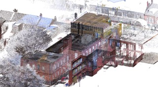
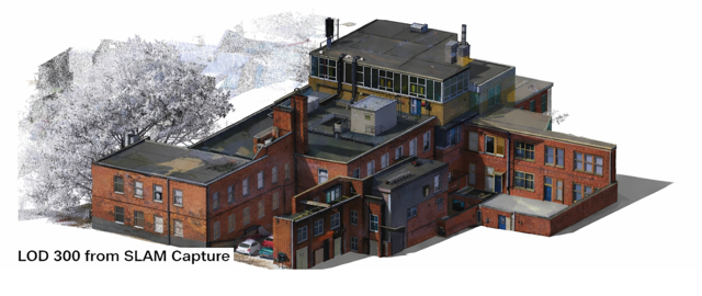
From Point Cloud to BIM
Our workflow delivers:
- High-density LIDAR point clouds
- Registered and geo-referenced datasets
- Clash-detection-ready 3D models
- BIM models to required LOD specifications
- As-built documentation
Whether you require a basic 3D visualisation or a fully detailed Revit-ready model, UK Air Comms provides reliable, structured outputs that integrate directly into your design workflow.
Designed for Telecoms, Construction & Renewables
Telecoms
- Exchange buildings
- Data centres
- Rooftop installations
- Equipment rooms
- Mast and compound modelling
Construction
- Existing building surveys
- Refurbishment projects
- Structural verification
- Pre-construction planning
Renewables
- Solar farm infrastructure
- Battery storage facilities
- Substations
- Wind turbine bases and compounds
The Benefits
- Single supplier for aerial + terrestrial data capture
- Reduced site revisits
- Improved design accuracy
- Fewer clashes during construction
- Faster project turnaround
- Professional, safety-compliant field teams
By combining aerial and internal LIDAR scanning, we remove uncertainty and give designers the complete picture from day one.
A Smarter Approach to Reality Capture
At UK Air Comms, we don’t just collect data — we deliver actionable digital assets that support smarter design, safer construction, and more efficient asset management.
If you’re planning a new project, refurbishment or infrastructure upgrade, speak to our team about how integrated drone and ground LIDAR scanning can support your BIM requirements.
Ready to get started?
Let’s talk about how we can help you and your business.